NATURE is in the spotlight next month when a programme of outdoors events, walks and activities is being held across the Chilterns Area of Outstanding Natural Beauty.
The Chilterns Conservation Board hopes the nature-based activities will inspire families, young people and adults of all ages to get out and explore the AONB.
A new October festival marks a month-long ‘season of celebration’ aiming to bring communities together and inspire people to explore and enjoy the heritage and landscape on their doorstep.
Naturalist, TV presenter and environmental campaigner Chris Packham will be the keynote speaker at the first ever ‘Chilterns Champions’ conference, discussing the importance of citizen science and how everyone can get involved.
There’s a chance to explore a new heritage trail around the Wycombe Rye, get creative in art workshops with local wildlife champions the Chiltern Rangers and enjoy a range of walks, talks and local produce tastings.
The festival runs from October 1-31 and is also designed to help support communities and businesses following the Covid-19 pandemic.
Also in October, the Chilterns Walking Festival is now in its seventh year and boasts more than 50 guided walks, activities and events over 16 days, running from October 17.
The walks, all guided by experienced leaders, provide opportunities to meet countryside rangers, farmers, archaeologists, historians, food producers and storytellers of the Chilterns.
Annette Venters, the Chilterns Conservation Board’s people & society officer, said: “We are delighted to be offering lots of new walks that showcase the best of our stunning landscapes, wildlife and local producers.
“There are still plenty of challenging hikes, but we’ve included a greater number of shorter walks too, with the emphasis on learning and discovery, meeting the people and producers of the Chilterns, and spending time in our inspirational landscape.”
The Chilterns Area of Outstanding Natural Beauty was designated in 1965 and stretches from Goring in Oxfordshire to near Hitchin in Hertfordshire. It is one of 38 AONBs in England and Wales and has a resident population of 80,000.
The Chilterns Conservation Board is an independent public body set up to conserve and enhance the natural beauty and increase awareness and understanding of the Chilterns AONB.
Guest writer Dr Wendy Morrison, project manager of Beacons of the Past, explains how local people can help uncover the secrets of our ancient Chilterns landscape
THE Chiltern Hills have been a focal point for people for thousands of years.
Any walk or ride through the Area of Outstanding Natural Beauty will take you past sites and monuments that stretch across huge spans of time and yet have survived the ravages of millennia and subsequent human activity.
In between Ice Ages, the region was sporadically occupied by people in search of game to eat and flint for making tools. These ancient artefacts are found all over the Chilterns, left by hunter-gatherers from 150,000 years ago up until the last of the Ice Ages (c. 11,000 years ago).
The warming landscape was filled with herds of deer and horse which were the main diet for the Mesolithic (9000-4500BC) people. The chalk streams and valleys were the perfect place for these nomadic groups.
The first substantial human alterations to the Chilterns begin in the Neolithic (4500-2200 BC) when farming technology begins to be practiced. Although the homes people lived in have long disappeared, we can see traces of what they were up to at places like Waulud’s Bank, a monumental enclosure in Marsh Farm, Luton.
We also know some of the places they buried their dead, in long barrows at Halton, Gerrards Cross, and Whiteleaf Hill. Some of the trackways they used to get around the landscape are still in use today!
The introduction of metals in the Bronze Age (2200-800 BC) to the Chilterns opened up a lot of possibilities to the people living here.
We can see the field systems that outline their agricultural activities at Pitstone Hill as well as their cemeteries – collections of barrow mounds – at Dunstable Downs and at Ivinghoe Beacon, where the Chilterns’ earliest hillfort was built around 1100 BC and where an incredible bronze sword was found.
The enigmatic earthworks collectively known as Grim’s Ditch are seen at various points across the AONB but can best be visited along the Ridgeway National Trail between Nuffield and Mongewell. Although little is known about these features, this particular section of Grim’s Ditch has been dated to the Iron Age.
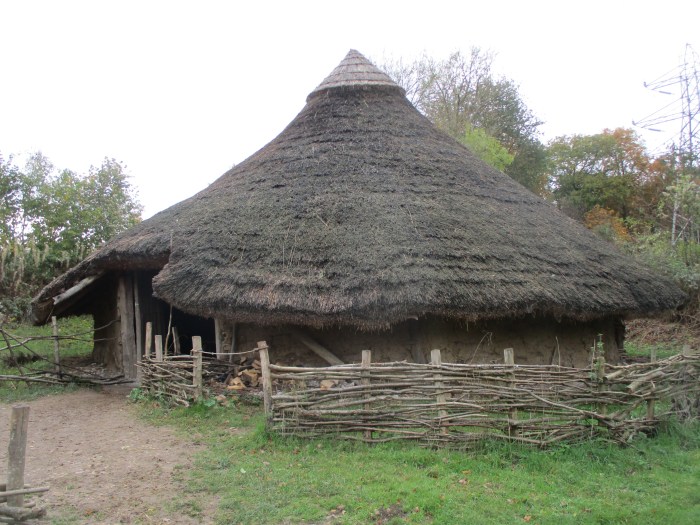
BRAVE NEW WORLD: an Iron Age farmstead at the Chiltern Open Air Museum
The period we call the Iron Age ushered in the ability to increase production of grain on the Chiltern fields. Iron tools meant that more difficult soils could be tilled, surplus crops could be grown, and the resulting prosperity mean that some people could show off their wealth and power through the construction of enormous earthworks.
Some of our Chiltern hillforts were certainly these kinds of expressions of power. Some, however, may have had more humble functions, such as places of refuge during conflict or enclosures for livestock.
In the Chilterns we have at least 20 hillforts, varied and unique, and with stunning views. Visit Pulpit Hill, Cholesbury Camp, Church Hill, or Medmenham Camp to take in a sample of these ancient monuments.
PULPIT HILL: the Iron Age enclosure PICTURE: National Trust / Hugh Mothersole
The Chilterns are steeped in prehistoric remains, and a new LiDAR survey of the entire area is revealing hundreds of new features.
Beacons of the Past – a National Lottery funded project to discover more about the Chilterns Iron Age hillforts – flew a bespoke LiDAR survey of the Chilterns earlier in the year, the first of its kind in this area and the largest high-resolution archaeological survey ever flown in the UK.
RAMPARTS: traces of the past at Pulpit Hill PICTURE: National Trust / Hugh Mothersole
Encompassing 1400 km2, the survey is revealing hundreds of new archaeological sites across Oxfordshire, Buckinghamshire, Hertfordshire, and Bedfordshire.
The project team are asking for the public’s contribution to view and interpret the results of the data gathered by the LiDAR visualisations; in many cases these will be people who may have spent decades exploring the Chilterns landscape or those who live in it, and who will bring a unique perspective to the project.
The team will offer comprehensive training and tutorials to teach LiDAR interpretative skills, allowing users to decipher the results of the data and enter the findings on an online portal at chilternsbeacons.org.
This will enable anyone in the world to discover new archaeological features in the Chilterns from their computer. Encouraging people from all walks of life to engage with a resource that is usually accessible to a handful of researchers will open up the landscape for greater understanding and appreciation, and when we appreciate and understand a place, we begin to take more active roles in caring for it.
Funded by a £695,600 grant from The National Lottery Heritage Fund and a number of partners such as the National Trust, Chiltern Society and local authorities, Beacons of the Past is providing a real focus for community and public involvement through techniques such as remote sensing and survey, practical excavation, and research, as well as a programme of events and educational activities.
Results will be used to further engage communities with their heritage, through work in schools, with youth groups, public talks and workshops. The new discoveries will be made available to the relevant Heritage Environment Record officers in the four counties and will also help heritage managers, archaeologists and policy makers to consider how they look after the Chilterns landscape.
LiDAR, standing for “Light Distance and Ranging,” also known as Airborne Laser Scanning (ALS), is a survey technique that has been used by archaeologists for nearly 20 years. It has aided in the discovery of new sites and is particularly important for its ability to show archaeology beneath tree cover.
The Chilterns Conservation Board was set up following the passing of the Countryside and Rights of Way Act, 2000, to conserve and enhance the natural beauty and increase awareness and understanding of the Chilterns AONB. The Board, which also aims to foster the social and economic well-being of local communities, is supported by Defra and all local authorities in the area.
For further information follow @ChilternsAONB, @Hillfortian, and @edpev7 or search #Chilforts. Dr Morrison can be contacted atwmorrison@chilternsaonb.org.